


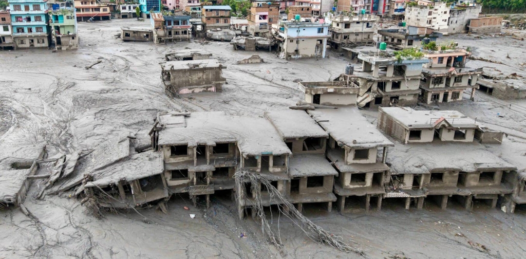

The catastrophic flood that killed hundreds of people in Nepal on Aug. 26, 2026, and left many more missing likely began with falling ice and rock crashing into the river below, but that wasn’t the end of the disaster. Days later, a new lake pooled behind the debris and then burst, sending more water streaming through the valley.
The destruction represents two of the ways rising temperatures, thawing permafrost and melting ice are increasing the risk of destructive floods in the Himalayas and other high mountain regions around the world.


I am a geologist and part of an ad hoc international group of 50-plus scientists who meet quickly after mountain disasters to analyze satellite images and field data to get information out to the public. This is what we’ve learned so far about the disaster and the region’s rising risks from climate change.
The flood disaster in Nepal
Evidence from satellites and seismic data we have reviewed suggest that an enormous mass of bedrock and glacier ice broke off a slope north of Langtang Lirung and slammed into the valley about 4,000 feet (1,200 meters) below – that’s a distance roughly three times the height of the Eiffel Tower. The landslide shook the earth hard enough to register as a magnitude 5.2 event on seismometers, the U.S. Geological Survey confirmed.
The result was a slurry of melting ice, rock and water that quickly flowed into the river.
We have a rough idea of how much ice fell, and it likely wouldn’t have been enough to trigger the magnitude of the flood that followed. One theory is that the rock and ice briefly dammed the valley, allowing water to back up in the river.
When that blockage broke, a wall of water rushed downstream – reaching towns, taking hundreds of lives and destroying infrastructure. Hundreds more people were stranded by the flood.
Second threat: The lake that formed, then burst
The disaster wasn’t finished when the first wall of water passed. Within a day, authorities warned that a new “barrier lake” estimated to hold a few million cubic meters of water had developed behind avalanche and flood debris where two rivers meet in Tibet, a region of China, before crossing into Nepal.
On Aug. 28, the barrier lake broke its bank and the river rose again. Helicopter search operations were briefly suspended while rescuers and residents on the lower banks scrambled to high ground. The immediate danger eased only when the barrier drained gradually rather than collapsing all at once.

This is the crux of why these events are so dangerous: A temporary, debris-choked dam can form in minutes, hold for hours or days, and fail with little warning. An avalanche-dammed lake often appears and disappears too quickly for conventional monitoring to catch.
Risks are rising
We’re seeing disasters like this happen frequently.
In 2021, a similar rock and ice avalanche in India’s Uttarakhand state sent about 950 million cubic feet (27 million cubic meters) of rock and ice – roughly 80% rock, 20% ice – cascading down from Ronti Peak. It destroyed one hydropower plant, badly damaged another and killed or left missing about 200 people, many of them dam workers.
In 2025, roughly 335 million cubic feet (9.5 million cubic meters) of rock and ice fell from the Birch Glacier in the Swiss Alps, burying most of the village of Blatten; only advance monitoring and the evacuation of more than 300 residents kept the death toll to one.
The number of glacial lakes has also increased around the world, raising the risk of outburst floods. And more mountain slopes are now at risk of landslides than in the past.
In 2023, thawing permafrost led to a rock collapse into South Lhonak Lake in Sikkim, India, generating a wave that burst through the moraine holding back the glacial lake. The outburst flood sent more than 13 billion gallons (50 million cubic meters) of water rushing down the mountain, damaging several dams, more than 25,000 buildings and more than 30 bridges.
Climate change is one major contributor to rising disaster risk.
The last 10 years have been the warmest on record globally, and that has accelerated snow and glacier melt.
Populations are growing, too, and these valleys are increasingly being used to generate hydropower. As countries build more infrastructure in these places, the hazard risk rises because more people and development sit in the flood’s path.
The valley where the latest disaster occurred held multiple hydropower plants – Nepal’s electricity authority said the flood knocked about a dozen major generation and transmission facilities offline. Bridges and a major border crossing, the Gyirong Port gateway between Nepal and China, were also destroyed. It became a catastrophe because of where the water, rock and mud landed.
Thawing permafrost, geology raise flood risk
Together with the neighboring Hindu Kush mountains, the rugged Himalayas that stretch across Asia contain one of the world’s largest volumes of ice. They’re sometimes called the “third pole” for that reason.
As temperatures have risen, their ice loss rates roughly doubled since 2000, according to studies from the Nepal-based International Center for Integrated Mountain Development, or ICIMOD.
And it isn’t only the glaciers that are melting. High mountain slopes are also held together by permafrost – ground that stays frozen year-round – with ice filling the cracks and joints in the rock like a natural cement. As that frozen ground warms and ice inside thaws, the cement weakens, and slopes that stood for thousands of years can lose their grip.
Meltwater from snow and ice seeps into cracks in the rock. Where it refreezes, it can pry those cracks wider. Where it stays liquid, it acts as a lubricant along the surfaces where rock and ice meet.
On a steep cliff, these water-filled fractures can sometimes be the difference between a face that holds and one that gives way all at once – sending millions of tons of rock and ice into the valley below in seconds.

Not every thaw ends in disaster. But rising temperatures steadily load the dice: more slopes lose their frozen glue, more meltwater works its way into the cracks, and the odds of a catastrophic collapse rise year after year.
In the 2021 disaster in Uttarakhand, thawing likely contributed to the collapse of a large slab of rock and ice on the face of Ronti Peak.
Early indications in Nepal point to a similar story: a large mass of rock and ice detaching from a mountainside and falling, triggering the August 2026 flood. Comparing satellite images of the site from before and after, first posted by my colleague Dan Shugar, we have also noticed that a lot of snow had disappeared in the days preceding the flood. That snowmelt had to go somewhere – and it may have supplied the water that lubricated the rockfall.
How to lower the risk
From a risk standpoint, some areas of these mountains are extremely dangerous today.
To help protect people, early warning systems are crucial. When a flood starts, people living farther down the valley might have several minutes to get to safety before the water arrives – and minutes are enough to save lives.
Nepal has warning systems in place, and they have been credited with preventing casualties in the past. But the warning systems rely heavily on river-level gauges, which work far better for monsoon floods than for a wall of water moving tens of meters per second – and the flood itself likely destroyed the very gauges the warning systems depend on.
Building redundancy into the system would help, such as adding seismic sensors that detect a large mass movement the instant it happens, sirens and loudspeakers in valley-bottom settlements, radio and satellite-based cell broadcasts that don’t rely on a single tower that a flood can sweep away, and automatic alerts triggered when an avalanche and sudden water and sediment level in the river jumps.
Knowing the risks can also improve permit decisions for hydropower dams, roads and buildings in high-hazard corridors – and it can push monitoring beyond the familiar checklist of large glacial lakes to hanging glaciers, steep ice-and-rock slopes, permafrost, and the short-lived debris dams that can be just as deadly.
Regional cooperation is also important. When rivers cross borders or a transboundary glacial lake has potential to fail, the disaster doesn’t stop at the border. The water that devastated Nepal began on the Tibetan side, and the barrier lake that threatened a second surge sat right on the frontier.






















Comments are closed.